

By Anna Rittenhouse
To say 2020 has been an unusual year would be an understatement.
Working from home, restrictions on indoor activities, outdoor gatherings limited by size—it has all required the world to get creative about how and where leisure time is spent. One thing is for sure, though: the pandemic has sent many people outside in search of fun.
According to NPD, an international market research firm, sales of outdoor recreational equipment like bicycles, kayaks, paddle boards and golf equipment have soared in 2020, up over 50% since last year. Likewise, people are flocking to state and national parks. In June, Cape Hatteras National Seashore, located on the Outer Banks of North Carolina, saw its second highest visitor count since its founding in 1953.
But what about really getting outside? Like hiking a mountainous trail or fishing in a secluded trout stream? These are activities the mountains of Tucker County, WV, have to offer.
While many people face physical limitations when it comes to outdoor activities, for many veterans, participating in outdoor activities may pose even greater challenges as they are complicated by a service-related injury or disability. That’s where the Patriots 4 Outdoor Resort located in Tucker County comes in.
Welcome to the Patriots 4 Outdoor Resort
Nestled in the mountains of Tucker County, the Patriots4 (P4) Outdoor Resort is a respite for wounded veterans and their families, service members and civilians. Founded by General Randy West, the nonprofit organization’s mission is to give back to those who have given so much through their service to our country by providing a means to enjoy outdoor activities at no cost.
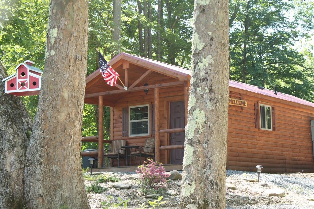
Located 180 miles from Washington, D.C., P4’s property is surrounded by majestic mountains and includes easy access to the Clover Run trout stream and frontage on the Cheat River. Veterans can enjoy outdoor activities such as hunting, fishing, kayaking, hiking and float fishing trips. Overnight lodging is available in handicapped accessible cabins and, for the more adventurous, camping in a personal camper or tent. Along with expert area guides, visitors of all abilities are provided access to mobility equipment such as a tracked wheelchair for fishing and sightseeing or a wheelchair-accessible, solar-powered, hydraulic-actuated raised hunting platform.
P4 prides itself on providing the very best outdoor experiences for its visitors, with safety and accessibility being of utmost importance. So, when the Clover Run trout stream’s failing banks threatened the stability of one of the handicapped accessible cabins, as well as safe trail and fishing access along the stream, something had to be done.
A Team is Born
It all started with a friendship, a shared love for hunting and fishing and an expertise in stream restoration. Dr. Paul Kinder is the director of the Natural Resource Analysis Center and the manager of the geospatial analytics program at West Virginia University (WVU). With more than 20 years of stream restoration experience, he is also a volunteer on the P4 board of directors.
“It all really started with a friendship,” says Kinder. “A friend introduced me to the Patriots4 organization several years ago, and I began volunteering to guide fishing and hunting trips. When the stream issue arose, I knew I could pull together the resources to support the P4 mission and help get the problem resolved.”
As the manager of the geospatial program at WVU, Kinder also knew that this was an opportunity for his graduate students to get some real-world experience while supporting an important charitable organization. After reaching out to several connections, a team was formed, including the West Virginia Division of Natural Resources and the U.S. Department of Agriculture Natural Resource Conservation Service, in addition to Kinder’s team of students at the WVU Natural Resource Analysis Center (NRAC) and geospatial analytics program.
Getting to Work
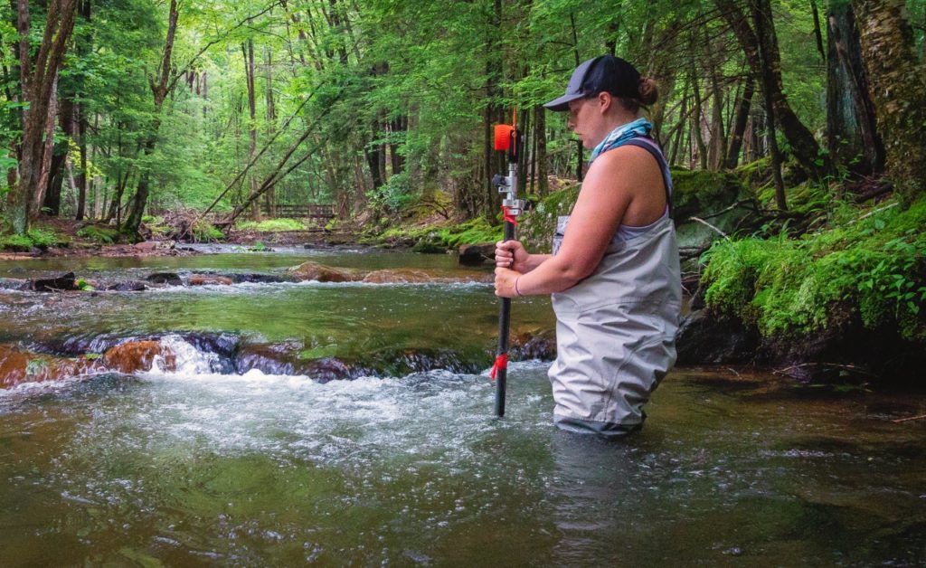
Over a three-year period, the team assessed and monitored the mile-long section of stream. As beautiful and tranquil as Clover Run appeared, the team soon realized the stream was very compromised and lacked good fish habitat.
Years of human influence and heavy flooding eroded the stream’s banks in multiple locations and contributed to the loss of in-stream structures and pools, which caused the fish habitat to be severely degraded. Eventually, the eroding stream banks began to threaten the integrity of the cabins and other structures, as well as the trail access for safe fishing by visitors.
Through careful assessment and planning, the team identified multiple restoration goals. Not only would they repair the stream bank that threatened the cabins and structures, they would also construct a handicapped accessible trail running the full length of the restored stream and restore the stream to optimal habitat for trout by re-establishing healthy fish and insect populations. When completed, the team would document the as-built conditions of the restoration efforts and monitor the stream over time to better understand which restoration practices deployed were the most effective.
An Emerging Technology for Conservation and Restoration
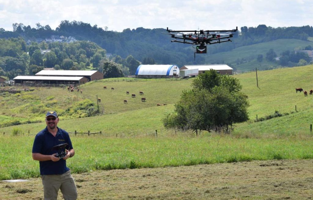
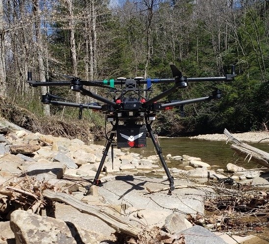
To aid in the assessment, planning and monitoring of the stream project, Kinder and the team employed the use of the drone-based LiDAR system designed and sold by 4D Tech Solutions, which is headquartered in Fairmont, WV.
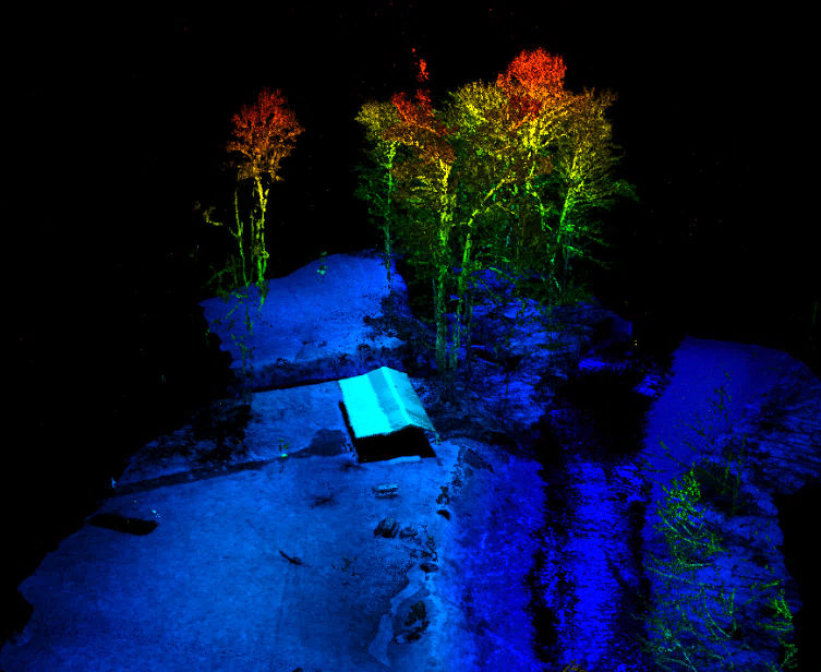
LiDAR, or light detection and ranging, is a method for measuring distances by illuminating a target with a laser light and measuring the reflection with a sensor. Differences in laser return times and wavelengths can then be used to make digital 3D images of the target.
“One of the most important emerging technologies in the fields of conservation and restoration is the use of drone-based LiDAR,” says Kinder. “Streams are dynamic, and one of the challenges we have is how to the assess, plan and then document pre-restoration and post-restoration conditions accurately. LiDAR is a powerful tool for this purpose.”
Compared to traditional surveying and monitoring methods, the use of LiDAR allows for the rapid inspection and monitoring of miles of stream corridor in very short time periods, providing precise, accurate and consistent data.
The high-resolution images or point clouds produced by the LiDAR system can be used to identify areas of erosion and poor habitat conditions to create flow and slope models, assess drainage areas, plan stream access and side trail development and document as-built structures for monitoring purposes.
LiDAR may be emerging to many in the field, but Kinder was an early adopter of the technology. He began using LiDAR technology when he was the director of science and technology at the Canaan Valley Institute and continued to utilize the technology as he completed his Ph.D. at WVU and took the helm at the NRAC. As the Clover Run project moved forward, Kinder found himself in the market for a new LiDAR system to deploy.
“It really was serendipitous,” he says. “I have known Brad DeRoos for the past decade, but we never had the opportunity to work together. His company had recently commercialized a LiDAR product that could be flown from small drones. It was perfect timing, and I was really impressed with what their system could do.”
DeRoos is president and CEO of 4D Tech Solutions. In 2019, 4D established a company division named RedTail LiDAR Systems that specializes in the development of LiDAR systems designed specifically for use on small drones and UAVs.
“Dr. Kinder has a great understanding of the technology and experience with real world applications,” says DeRoos. “As a Navy veteran myself, when the opportunity to utilize the RTL-400 for the Patriots 4 project arose, it was an opportunity we couldn’t pass up. And educating students with this technology is icing on the cake.”
Designed specifically for use on small drones, the RTL-400 incorporates an innovative icroelectromechanical system mirror-based laser scanner that rapidly and evenly distributes all laser pulses to the ground, moving side to side 400 times per second. Combined with a laser pulse rate of up to 400,000 pulses per second and an optimized scan angle of 35 degrees, the point cloud images that are generated are very high resolution and highly accurate. The RTL-400 can fly at an altitude of up to 400 feet and up to a speed of 35 miles per hour.
LiDAR Images Capture it All
The P4 restoration team got to work. The first phase of the project was completed by December 2019 and included the bank stabilization near the cabins and the construction of 22 fish habitat enhancements and bank erosion structures, creating an ideal habitat for trout and other fish species.
The Clover Run stream corridor was flown with the RedTail LiDAR System’s RTL-400 to document the as-built condition of the stream, creating highly accurate, high-resolution 3D images or point clouds of the area. The stream was mapped in a single 20-minute flight at an altitude of 262 feet and at a speed of 18 miles per hour.
Phase 2 of the project was completed in June 2020. Phase 2 included the construction of another 20-bank erosion and habitat enhancement structures for a total of 40, as well as a handicapped accessible trail traveling the length of the trout stream.
To monitor the health of the stream and measure the efficacy of the structures installed, the Clover Run stream will be flown once a year with the RTL-400, providing the same highly accurate, high-resolution 3D imagery for comparison and to monitor its long-term health.
“Having the opportunity to develop an innovative product like the RTL-400 in West Virginia, partnering with an organization like Patriots 4 and educating students with this innovative technology—it just doesn’t get any better than that,” says DeRoos.
About the Author

Anna Rittenhouse is the senior marketing specialist for 4D Tech Solutions Inc. She holds a master’s degree in journalism from West Virginia University and has more than 20 years of experience in the marketing, public relations and fundraising fields, successfully building long-term, strategic relationships through the use of new and traditional media outlets.